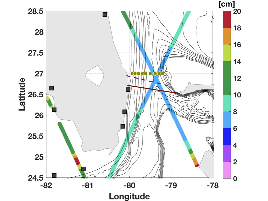
Location of CPIES array in the Florida Straits at 27˚N (yellow dots)
Record high water level at RSMAS in November 2019
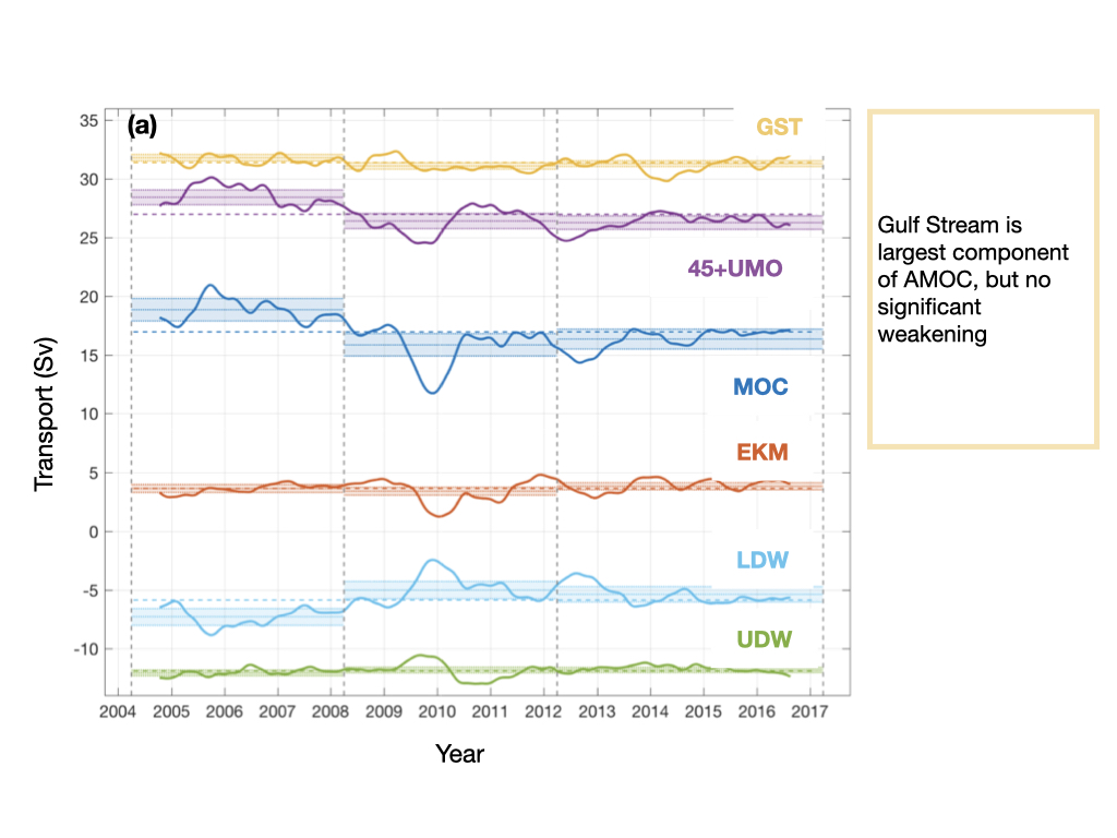
Gulf Stream transport is the largest component of the AMOC
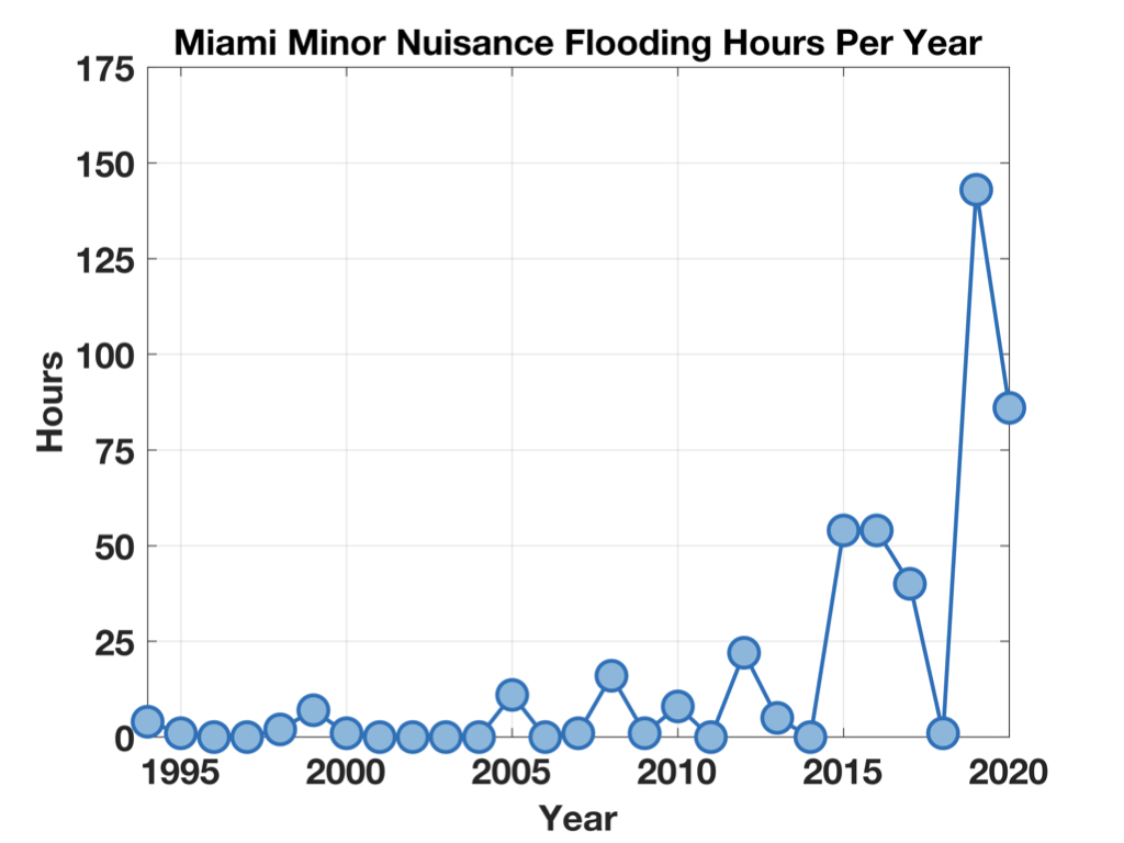
Flooding in Miami is becoming more frequent
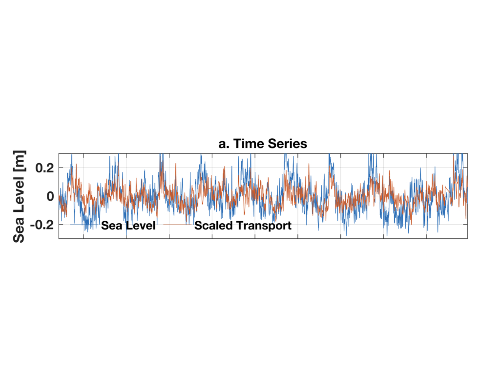
The time series of Gulf Stream transport and sea level at West Palm Beach are correlated.
World Ocean Day:
Key Points: We will deploy an array of instruments across the Florida Straits to monitor continuously the Florida Current transport and its relationship with coastal sea level.
Overview: The transport of the Gulf Stream, as measured by cable in the Florida Straits since the 1980s, is significantly correlated with US East coast sea level all the way from Key West to Cape Hatteras. The simple physical model for this relationship is well established and is based on geostrophy. This relationship has been used to suggest that a weakening Gulf Stream, related to the ongoing weakening of the Atlantic meridional overturning circulation (AMOC) with anthropogenic climate change, will continue to result in a hot spot of sea level rise and flood return along the US East Coast. However, the AMOC observing system shows that while the AMOC has measurably weakened over the last 15 years, the Gulf Stream has not. Moreover, only 30% of the variance in coastal sea level can be related to Gulf Stream transport, with many periods, at multiple timescales, when they are not coherent. We need to better understand the relationship between coastal sea level and Gulf Stream variability to confidently assert the influence of ocean circulation on future US East Coast sea level rise. We hypothesize that: (1) Decoupling of coastal sea level and Gulf Stream transport is related to observable modes of mass loading and heat content variability across the Florida Straits. (2) These modes of variability are important, affecting meridional heat transport through the Florida Straits as well as coastal sea level at multiple time scales from days to decades. (3) Understanding these modes will improve estimations of AMOC heat transport and coastal flood risk. To explore these hypotheses we propose to instrument the Florida Straits with CPIES (Current, Pressure, Inverted Echo Sounder) at the latitude of the transport cable. We will continuously observe the cross-shore variability of the Florida Current in relation to coastal sea level and transport for the first time. Our objectives are to use these new in situ data to: (i) Characterize modes of variance of sea surface height, mass loading, and heat content across the Florida Straits at time scales from days to years; (ii) Understand how coastal sea level and heat transport are linked to these modes and how their relationship with cable transport is modified by them; and (iii) Look for fingerprints of these modes in more easily observable parameters that could be used alongside cable transport to improve estimations of flood risk and AMOC heat transport in the long term. Intellectual Merit:The simple geostrophic model commonly used to relate Gulf Stream transport to US East Coast sea level is that of a singular parameter sea surface slope across the current: A weaker transport and the slope decreases, raising sea level at the coast. However, this model assumes zero mass and heat content variability of the western boundary layer, an assumption that can break down on multiple time scales. With continuous measurements across the Florida Straits, as proposed here, we can characterize mass and heat content variability and relate them to coastal sea level and cable transport for the first time. These modes, and their surface fingerprints, can then be used directly to improve on the linear model of coastal sea level response to dynamic oceanic change. We will also capture sub-seasonal variability of Florida Current heat transport that is currently unresolved by the AMOC observing system.