Link to Lecture 6 slide show: 6_forcing.pdf
Tides contribute to the mean, open ocean circulation in terms of mixing. Winds directly drive ocean currents close to the surface (and drive deeper circulation via convergences and divergences - later). Heating drives the ocean circulation indirectly via buoyancy fluxes.
1. Direct forcing of Ocean
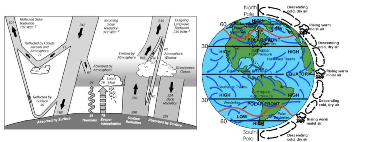
heat budget - sunlight
evaporation
infrared emission
sensible heat
winds
tides
2. Tides
Tidal forcing is the result of the gravitational pull of the moon and the sun. The earth-moon-sun system is in balance, with gravitational forces balancing the centripetal forces associated with their orbits around the centre of mass of the system. The sun is much larger than the moon, but also much farther away, so the solar tides are half the size of lunar tides.
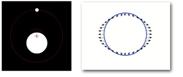
How do tidal currents result? Consider the earth-moon system only. The gravitational force of the moon is matched by the centripetal force of the earth rotating around the centre of gravity of the earth-moon system (which is 3/4 of the way from the centre of the earth to its surface). But, if we look at a place on the surface of the earth that is closer to the moon, there is an excess of gravitational force. On the surface of the earth farthest from the moon, the centripetal force will be slightly greater. This causes two tidal bulges, one towards the moon and one away from the moon. Since there are two tidal bulges at any one time and the earth rotates once per day, then we expect two tides per day: the forcing is SEMI-DIURNAL.

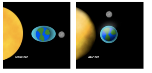
There are many tidal constituents, in addition the the semi-diurnal due to the interaction of the solar and lunar tidal forcings at different periods and due to long-term changes in the orbits of the earth-moon-sun system. The principal lunar and solar tides “beat” at periods of fourteen days, acting in concert to produce SPRING tides and in opposition to produce NEAP tides.

spring tide neap tide
Because of the cyclical nature of tides, tidal height and tidal currents can be predicted along the coasts using measurements collected over many years (18 years to account for some orbital variations) and harmonic analysis. The most accurate estimates of open ocean tidal currents come from satellite altimeter data.
When considering the large-scale, open ocean circulation the effect of tidal currents is small. Averaged over a day or two the tidal currents slosh back and forth with little mean effect on the flow. Therefore, in the case of snapshots of ocean circulation from hydrographic data, for example, tides might be considered noise and need to be removed. For time series data, we often filter out tides using low-pass filters, and concentrate on the longer time scale flows. However, the tides do effect the mean circulation in a very important way that cannot be filtered out - through MIXING. Tidal mixing is the result of the high frequency fluctuations of tidal currents and of breaking internal waves. This important tidal mixing is “parameterized” in the equations of motion as EDDY VISCOSITY AND EDDY DIFFUSION - a transfer of energy from large scales to small scales.
3. Winds
In each hemisphere there are three main zonal bands of winds, driven by the vertical circulation of the atmosphere (see Heat section below). Close to the pole there are easterlies, at subpolar latitudes there are westerlies, and at subtropical latitudes there are the trade winds. The trades are northeasterly in the northern hemisphere and southeasterly in the southern hemisphere. At the equator (just north) is the Intertropical convergence zone where winds are light.
Seasonality: Winds are stronger during winter than summer, and in the northern Indian Ocean and northwest Pacific winds change direction due to the Asian monsoon.
Winds blowing over the ocean exert a STRESS on the ocean surface that is proportional to the wind speed squared. The wind stress accelerates the flow in the upper ocean, causing a velocity shear, du/dz. The resulting force on a parcel of water is proportional to the vertical gradient of this velocity shear. The depth over which the wind stress directly accelerates ocean currents is about 50 - 100 m and is called the EKMAN LAYER.
4. Heat budget
Important to remember that the atmosphere does not just drive the ocean, but also the ocean drives the atmosphere: it is a COUPLED DYNAMIC SYSTEM.
The ocean is the dominant source of heat that drives atmospheric circulation: the uneven distribution of sea surface temperature (SST) drives winds. Also, evaporation from the tropical oceans transfers heat, in the form of water vapour, into the atmosphere. The heat is released when the water vapour condenses and it rains.
The atmosphere is almost transparent to sunlight, directly absorbing only 20%. Half of the sunlight reaching earth is absorbed by the ocean. Most heat stored by the ocean is released locally. The remainder is transported to higher latitudes by ocean currents (thermohaline circulation). Oceanic heat storage and heat transports help moderate the seasons at high latitudes. Oceanic heat transport is not steady and may play a role in the development of ice ages and rapid climate change.
Surface heat fluxes:
Insolation, Q_SW, function of latitude, time of day, cloudiness, season
Latent heat of evaporation, Q_L, function of wind speed and relative humidity
Net long wave, Q_LW, function of sea surface temperature
Sensible heat (conduction), Q_S, function of air-sea temperature difference and wind speed
In the mean there is large heat gain by the ocean in the tropics and large heat loss over the western boundary current systems. The primary balance at low and mid latitudes is between insolation and evaporation. Measurements of surface heat flux come from ships and more recently from satellites. Flux estimates in the Southern Ocean are poor due to a lack of measurements. Climatologies have typical global misbalances of 30 W/m2.
Interesting to note that atmosphere warms primarily as a result of RAIN and long-wave radiation from the ocean (not directly from sun). Since overall the atmosphere and ocean gain heat in the tropics and lose heat over the poles there must be a transport of heat by the ocean and atmosphere from the equator towards the poles. This north-south transport is called the MERIDIONAL HEAT TRANSPORT. It peaks at 6 PW at 35 degrees latitude. About one quarter of this transport is carried by the ocean.
Resources
Climatologies of wind stress and heat fluxes: COADS, NCEP, ECMWF, Quikscat, NOC (formerly SOC) climatology.
Reading
Stewart, chapters 4, 5, and 17.
Aug 2007


